Map View

Displaying still images on a map
Map View is a program that enables you to display or change the recorded location of a still image with recording location information taken by your camera on the map. When a still image does not have the recording location information, you can decide a recorded location and save the still image with the recording location information.
Starting the Program
- In the main window, select the still images that you want to display on a map.
-
Click
 at the top of the window.
The Map View main window appears.
at the top of the window.
The Map View main window appears.
When you select the still images with recording location information, the recorded location is displayed on the map.
When you select the still images without recording location information, a map is displayed to decide the recorded location.
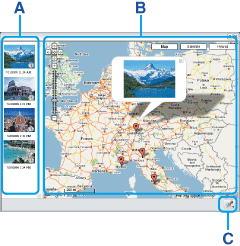
The parts and functions of the main window are described below.
Maps and satellite images powered by Google Maps mapping service.
A Thumbnail list Thumbnails of the selected still images are displayed here. If you select a still image with recording location information, a thumbnail is displayed with  .
.
B Map area The recorded locations of still images with recording location information that are displayed in the thumbnail list are shown with a mark on a map. When you select a still image without recording location information in the thumbnail list, a mark to decide a recorded information is shown on a map.
The marks displayed on a map are as follows.
When you click a mark or a still image with recording location information in the thumbnail list, the still image recorded in that location appears in a balloon.
Show the recorded location of a still image with recording location information. 
Change the recorded location by dragging and dropping the mark on a map. 
Show the recorded location that has been changed.
To change the recorded location of a still image with recording location information
Click that is next to a still image in the balloon, then drag and drop the mark that shows the recorded location of a still image on a map.
You can display a still image without recording location information on a map by clicking the image in the thumbnail list. A recorded location of a still image can be decided by dragging and dropping the mark that shows the recorded location on a map.
To enlarge a still image in the balloon
By clicking the still image in the balloon, you can display the larger image. When you click the enlarged image, the display returns to the balloon display.
You can move or zoom the map in or out using a mouse.C  button
You can save the recording location information of a still image that has been changed the recorded location, or a Selected Settings of still images displayed in the thumbnail list. You can also display or delete the saved Selected Settings.
To change the recording location information of a still image or save Selected Settings
Click and select [Save Map View as a new file] or [Save Map View] from the displayed menu.
When you select [Save Map View as a new file], enter a name in [Name of the Map View] and click [Save]. Hint
Hint- Selected Settings is saved to [My Documents] - [Map View].
To display saved Selected Settings
Click and select one of the saved Selected Settings from the displayed menu. Then, you can see the still images in the thumbnail list and the recorded locations with a mark on the map.
To delete saved Selected Settings
Click and select one of the saved Selected Settings from the displayed menu.
Then, click again and select [Delete selected Map View] from the displayed menu.
 Notes
Notes- The maximum possible number of saved Selected Settings is 255.
- When you select one of the saved Selected Settings but it cannot find a still image,
 appears in the thumbnail list. To display the still image again, you need to select the still image to display using Picture Motion Browser and then start Map View.
Exiting the Program
Click  at the upper-right corner of the window.
|
Copyright 2007 Sony Corporation |
P0056-01-US |