Using Map View

Map View is a program that enables you to display or change the recording location of a video or photo that has recording location information on a map. You can also display the route you followed when you took the videos and photos by importing GPS log files. When you select videos or photos that do not have recording location information, a map is displayed to help you determine the recording location.
-
In the main window, select the videos or photos you want to display on a map.
-
Click
 .
.
The Map View main window is displayed.
When you select the videos or photos with recording location information, the recording location is displayed on the map.
When you select the videos or photos without recording location information, a map is displayed to determine the recording location.
Maps and satellite images powered by Google Maps mapping service.
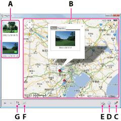
A Thumbnail list Thumbnails of the selected videos and photos are displayed here.
If you select a video or photo with recording location information, a thumbnail is displayed with . By dragging and dropping onto the other videos or photos, you can copy the location information.
By right-clicking a thumbnail, you can change the location information or delete the thumbnail from the list.B Map area The recording locations of videos and photos with recording location information that are displayed in the thumbnail list are shown with a mark on a map. <Details>
You can move or zoom the map in or out using a mouse.C  button
You can save changed recording location information of videos or photos, or videos or photos selected in the thumbnail list. You can also display or delete the selected videos or photos saved in the thumbnail list. <Details> D  button
Using the menu displayed by clicking , you can send videos and photos by e-mail or export files for use with Google Earth. <Details>E  button
By clicking , you can display the [Track settings] window. In the [Track settings] window, you can change the settings for route display, such as the color of a route display, etc. <Details>
( is displayed only when GPS log files that can be displayed have been imported to your computer.)F  button
By clicking , you can display a list of GPS log files. <Details>
( is displayed only when GPS log files that can be displayed have been imported to your computer.)G  button
By clicking , you can play the videos and photos in Map View as a slide show.
 Hints
Hints
- You can add and display videos and photos by dragging and dropping them from “PlayMemories Home” to the Map View main window.
- To delete the location information of videos or photos, select [Delete Position Information] in the [Edit] menu of “PlayMemories Home.”
- When you record videos with a camera equipped with the GPS function, the location information may remain in the video files.
About recording location information and marks
The marks displayed on a map are as follows.
 |
Shows the recording location of a video or photo with recording location information. |
| Shows the recording location and direction of a video or photo with recording direction information. | |
 |
By dragging and dropping the mark on a map, you can change the recording location. When you edit the recorded direction of a video or photo, the mark is displayed as a target of the recording direction. |
 |
Shows grouped videos and photos. If you click , each mark of videos and photos included in the group is displayed. When you add over 30 videos and photos to the map at the same time, the ones located together are grouped automatically. Also videos and photos are grouped when you select multiple videos or photos in the thumbnail list, and drag and drop them onto the map. |
When you click a mark or a video or photo with recording location information in the thumbnail list, the video or photo recorded in that location appears in a balloon.
By clicking a photo in a balloon, you can enlarge the photo. When you click the enlarged image, the display returns to the balloon display. By clicking a video in a balloon, you can play back the video.
To determine or change the recording location of a video or photo
To change the recording location of a video or photo with recording location information, click the [Properties] tab in the balloon of a video or photo, and click [Edit position], and then drag and drop on the map.Videos or photos without recording location information can be displayed on a map by clicking them in the thumbnail list, or by dragging and dropping them from the thumbnail list to the map. To determine the recording location, drag and drop
on the map.To change the recorded direction of a video or photo
The [Edit direction] button is displayed on the [Properties] tab in the balloon of a video or photo with recording direction information. When you click [Edit direction], the marks of videos or photos on the map other than the one that you have selected are hidden temporarily. Click anywhere on the map, and change the recording direction of the photo or video.Importing GPS log files and displaying a route
You can display a route on a map by importing GPS log files recorded using a camera supporting the GPS recording function or a GPS unit.
When you click , a list of GPS log files is displayed, and you can display a route by selecting a GPS log file.
When you click , the [Track settings] window is displayed and you can change the settings for route display, such as the color of a route display, etc.
-
To import GPS log files from your camera to a computer, make the GPS log acquisition settings by selecting [Settings] - [Import] form the [Tools] menu.<Details>
GPS log files that have not been imported yet will be imported when you import videos and photos the next time. - When you record GPS log files using a GPS unit, import the resulting GPS log files to your computer using “GPS Image Tracker” to display the route.
- When you click [Tracks for the Same Day], the route obtained on the same day the videos and photos shown in the thumbnails on the left of the window were taken is displayed on a map.
- By selecting a GPS log file and clicking
 , you can delete unnecessary GPS log files.